|
|
Post by Aardvaaks on Oct 25, 2009 9:01:38 GMT 10
|
|
|
|
Post by shatnerswig on Oct 25, 2009 15:24:38 GMT 10
good job this is one of those unsolved
|
|
Deleted
Deleted Member
Posts: 0
|
Post by Deleted on Oct 25, 2009 18:33:59 GMT 10
Thought this might fit here, matbe this mechanism could have been used to map the longitudes.
It, like the map, is something that should not exsist, at least according to current accepted wisdom.
|
|
|
|
Post by Aardvaaks on Oct 25, 2009 20:31:18 GMT 10
The Wallingford clock although a differant device still uses the same princles of gears and cogs, but how much smaller the Antikythera object is for observing/predicting star and planet motions, also similar to the Astrolabe below, but far more complex and the size of a clock so more portable! Astrolabes are thought to have originated from 200 years BC.  |
|
|
|
Post by brillbilly on Oct 26, 2009 4:38:51 GMT 10
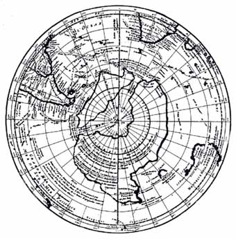 ...The Philippe Buache map of Antarctica, made in Paris in 1737, a century before Antarctica was discovered. Evidently copied frm maps surviving from ancient times, it shows Antarctica as two separate land masses, a fact no established until the Geophysical Year of 1958 through ice soundings, but evidently known to navigators of prehistory, who may have visited Antarctica before it was covered by ice. 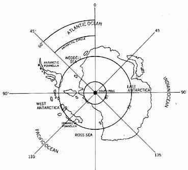 ..Sketch map of Antarctica as it would appear without the icecap, now more than two miles thick. The Antarctic continent, without the ice, would not be one land mass but two, separated by water. 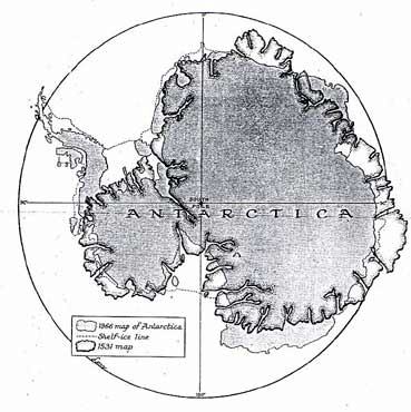 ...The Oronteus Finaeus Map of Antarctica redrawn on the modern equidistant azimuthal polar projection, compared with the modern map of Antarctica on the same projection (Christian Science Monitor) A comparison of the Oronteus Finaeus Map with the map of the subglacial land surfaces of Antarctica produced by survey teams or various nations during the International Geophysical Year (1958) seems to explain some of the apparent short-comings of the Oronteus Finaeus Map, and at the same time throws some light on the question of the probable extent of glacial conditions when the original maps were drawn. |
|